
Papua New Guinea Exploration
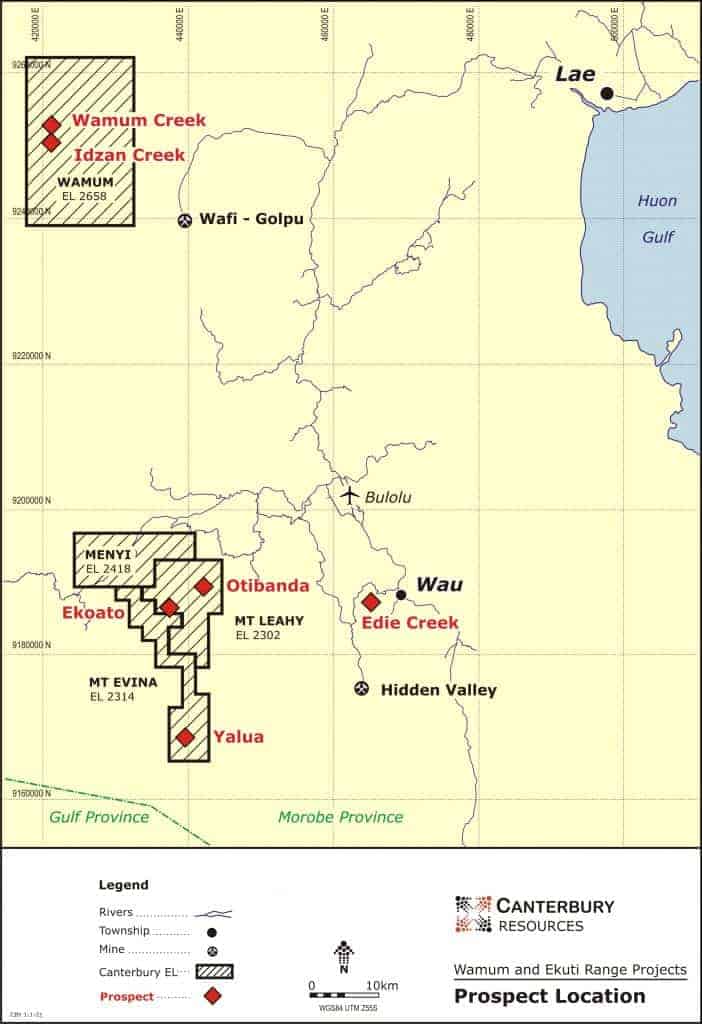
In PNG Canterbury has three project areas; Ekuti Range and Wamum on the mainland, and Bismarck on Manus Island.
PNG is renowned for its abundant mineral wealth, including world-class copper and gold assets. Its unique geology largely results from its position on the interactive plate tectonic boundary between the cratonic Indo-Australian plate to the south and the oceanic Pacific Plate to the north. Since the Cretaceous, uplift and deformation has occurred because of collision between these plates.
On mainland PNG, which hosts the Ekuti Range and Wamum projects, porphyry and epithermal style mineralisation occurs associated with two spatially and temporally distinct magmatic arcs. The early Maramuni arc (mid-Miocene age) was active in the northern part of mainland PNG and deposits such as Freida River and Yandera are associated with this arc. A much younger arc is associated with high level intrusions and extrusive volcanism in central and southern PNG, and the Ok Tedi, Porgera, Wafi-Golpu, Hidden Valley and Tolukuma deposits are associated with this arc.
Canterbury’s PNG Assets:
Ekuti Range (100%) – EL2302 and EL2314
Strategic tenements are established in a well-endowed mineral province. Epithermal gold rich lodes have been identified along strike of the Hidden Valley gold mine’s Hamata lodes, overlying interpreted large scale, metal rich copper-gold porphyry systems. Initial drilling results at the Ekoato prospect support this interpretation.
Wamum (100%) – EL2658
Historical drilling has encountered significant gold and copper mineralisation at the Wamum Creek and Idzan Creek porphyry systems, located immediately northwest of the major Wafi-Golpu Project. Canterbury has determined Inferred Mineral Resources at Idzan Creek (137.3Mt at 0.53g/t Au & 0.24% Cu) and Wamum Creek (141.5Mt at 0.31% Cu & 0.18g/t Au).
Bismarck Project (100%, Rio Tinto earning up to 80%) – EL2378 & EL2390
Through a combination of geophysical surveys, geochemistry and geological interpretation, project manager Rio Tinto has identified potential large-scale concealed porphyry copper-gold-molybdenum targets adjacent to or beneath extensive zones of advanced argillic altered lithocap.
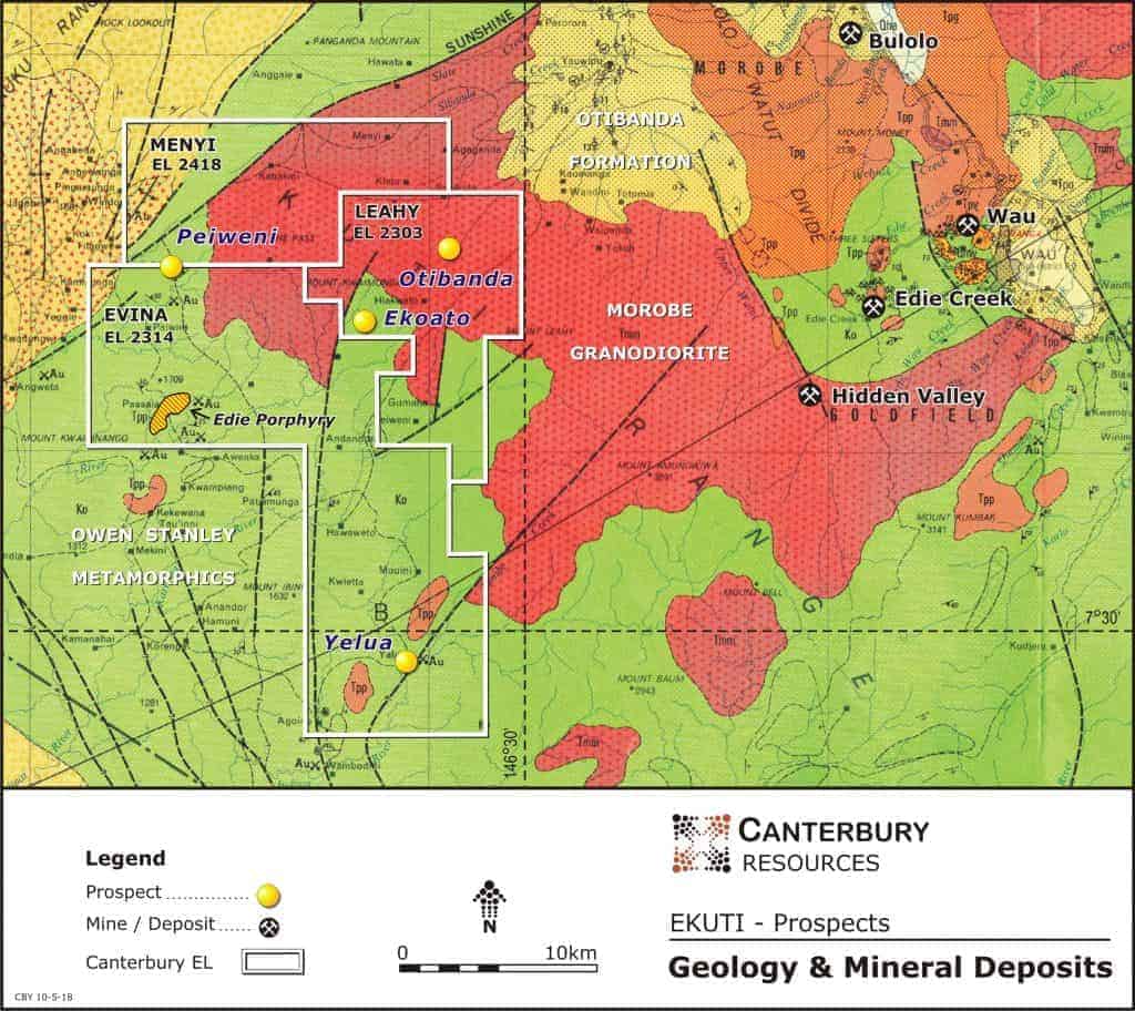
Ekuti Range Project
The 100% owned Ekuti Range Project [EL2302 (Mt Leahy) and EL2314 (Mt Evina)] in Morobe Province PNG is in a well-endowed metallogenic belt that hosts world class epithermal and porphyry style deposits, including the Hidden Valley gold mine (150-200koz pa gold) and the Wafi-Golpu project (2020 Mineral Resources 27Moz gold, 9Mt copper).
The Project has reasonable access to infrastructure by PNG standards, being approximately 20km southwest of the regional town of Bulolo (a former mining centre and now a hub for forestry) and 80km southwest of the major port city of Lae (PNG’s second largest city). The Menyamya Road, which links to Lae, crosses the north-western portion of the tenements within the Menyi license area.
The Mt Leahy and Menyi tenements lie within the Ekuti Dividing Range which reaches heights of up to 3,100m. The Mt Evina tenement adjoins to the south and west and covers the western foothills of the range. The western side of the range is drained by the Kapau, Kariba and Indiwa Rivers which drain to the south to the Gulf of Papua. The eastern side is drained by the Watut River, which discharges into the Huon Gulf at Lae.
Surprisingly, since discovery of the Ekoato and Otibanda prospects by CRA in the late 1980s, relatively limited exploration has been conducted in the Ekuti Range area.
Triple Plate Junction (“TPJ”) investigated the area from 2006 to 2013 focusing on high grade Cu-Au lodes at Otibanda, Weke and Sepanda (Kopekio). Limited shallow drilling returned encouraging results e.g.
- OTI 003 – 2.2m at 16.6g/t Au, 2.0% Cu
- OTI 006 – 2.5m at 15.3g/t Au, 0.3% Cu and 0.8m at 25.6g/t Au, 0.4% Cu
- OTI 007 – 1.0m at 17.5g/t Au, 0.6% Cu
- OTI 008 – 1.1m at 20.1g/t Au, 0.2% Cu
Newmont, in joint venture with TPJ, recognized that the lodes were porphyry related and completed airborne geophysical surveys (100m line spacing, heli-magnetics and radiometrics) in 2010 and 2011. However, they withdrew from PNG before undertaking meaningful follow-up based on interpretation of the data.
Since the granting of its initial tenement in 2014, Canterbury has undertaken multiple investigative programs, including reconnaissance mapping, sampling, petrology and geophysical interpretation. Results have been encouraging, with widespread mineralisation encountered across multiple prospects. In part, this work has been supported by technical input from Anglo American and Rio Tinto.
During 2014 Canterbury merged and interpreted the data from the Newmont magnetic surveys with existing regional survey data, identifying at least ten discrete magnetic anomalies of moderate to high amplitudes, about the size and geometry for the magnetite rich potassic core of a porphyry system. Similarly, petrological investigations at selected prospects suggests the causative quartz monzodiorite porphyry intrusives have clearly exsolved metal bearing fluids into enclosing rocks dominated by pyrite, pyrrhotite and chalcopyrite mineralisation.
Field follow-up has been undertaken at selected prospects, with a representation of the relative position of the most advanced prospects illustrated on the following interpreted schematic section of a south west Pacific porphyry system.

The most advanced targets identified were Otibanda, Mt Leahy lithocap, Ekoato and Yelua, culminating in a four-hole, heli-supported drill program in 2019 at Ekoato. The best assay result was 18m at 6.23g/t Au, 13.0g/t Ag and 0.18% Cu in drill hole EK004.
The results of the drilling clearly demonstrated the potential for high-grade gold and copper in the lode structures at Ekoato. Similar narrow, high-grade results are reported from drilling by TPJ at the Otibanda and Waikanda lodes. These lodes are laterally extensive, potentially vertically extensive, and wide enough for underground mining. The Kainantu gold mine in the eastern Highlands is an excellent analogue of a successful mining operation with similar geological and mining attributes. recent soil sampling and mapping by Canterbury has further defined the extent of these lodes and the data is being utilised to generate potential drill targets.
At Ekoato, an intrusive related hydrothermal breccia was also intersected over broad intervals in drill holes EK002, EK003 and EK004, with the footprint indicating a large intrusive related system. The New York breccia at Ok Tedi is a good analogue: the breccia has developed up the margins of a granodiorite, a similar setting to Ekoato.

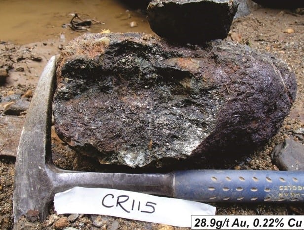
Mineralised massive sulphide float samples, Kaiwama Creek

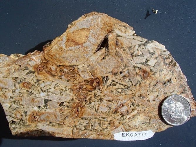
Clay alteration Mt Leahy lithocap in outcrop (left) and Ekoato sandstone breccia float


Altered metasediment Ekoato (left), mineralised shear Ekoato (right) worked by artisanal miners
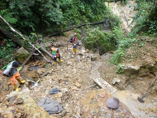
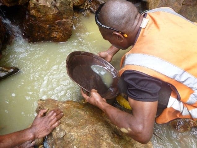
Artisanal Au workings Ekoato (left), CBY geologist panning

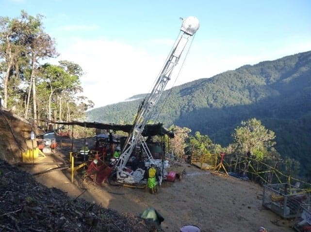
Ekoato drill camp 2019 (left), drill hole EK001 (right)

Brecciated metasediment with quartz-k-feldspar-biotite-sulphide infill and distinct k-feldspar alteration rims around clasts EK002 ~200m

Brecciated and altered metasediments EK004 ~200m

Ekoato prospect (EL2302) drill plan on geology, magnetics and ridge and spur soil gold geochemistry

Drill section Ekoato
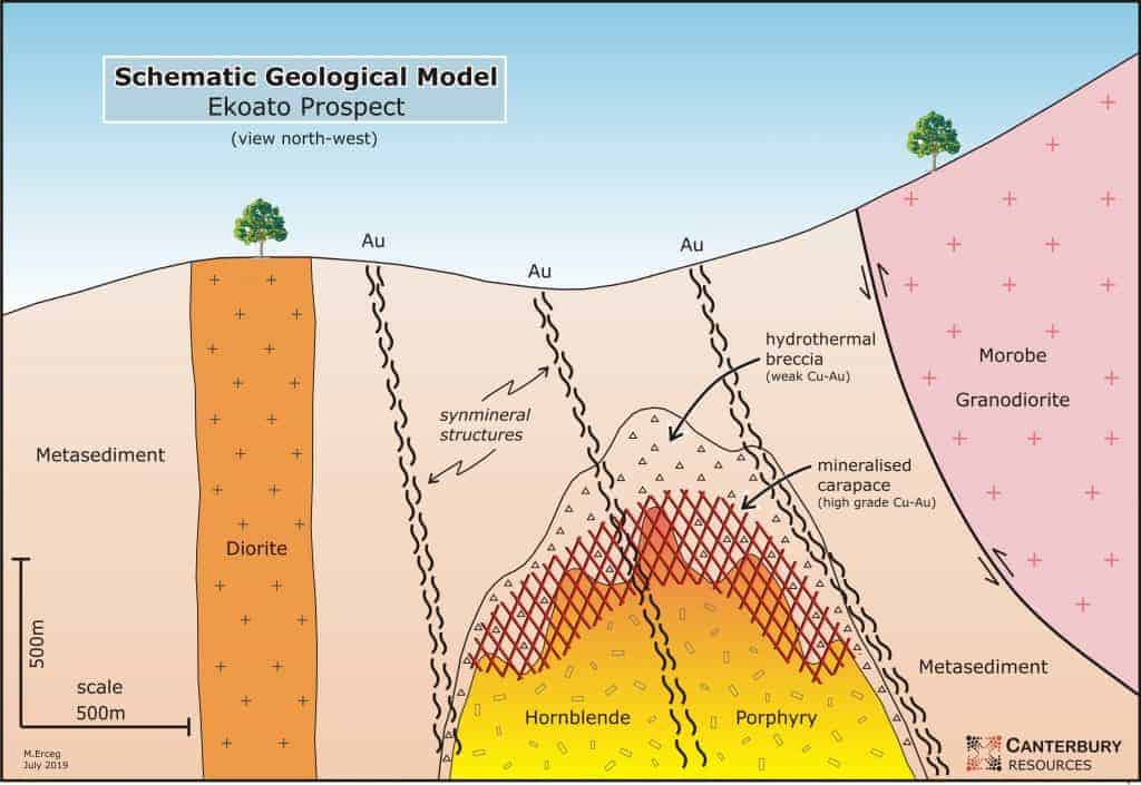
Geological model, Ekoato prospect
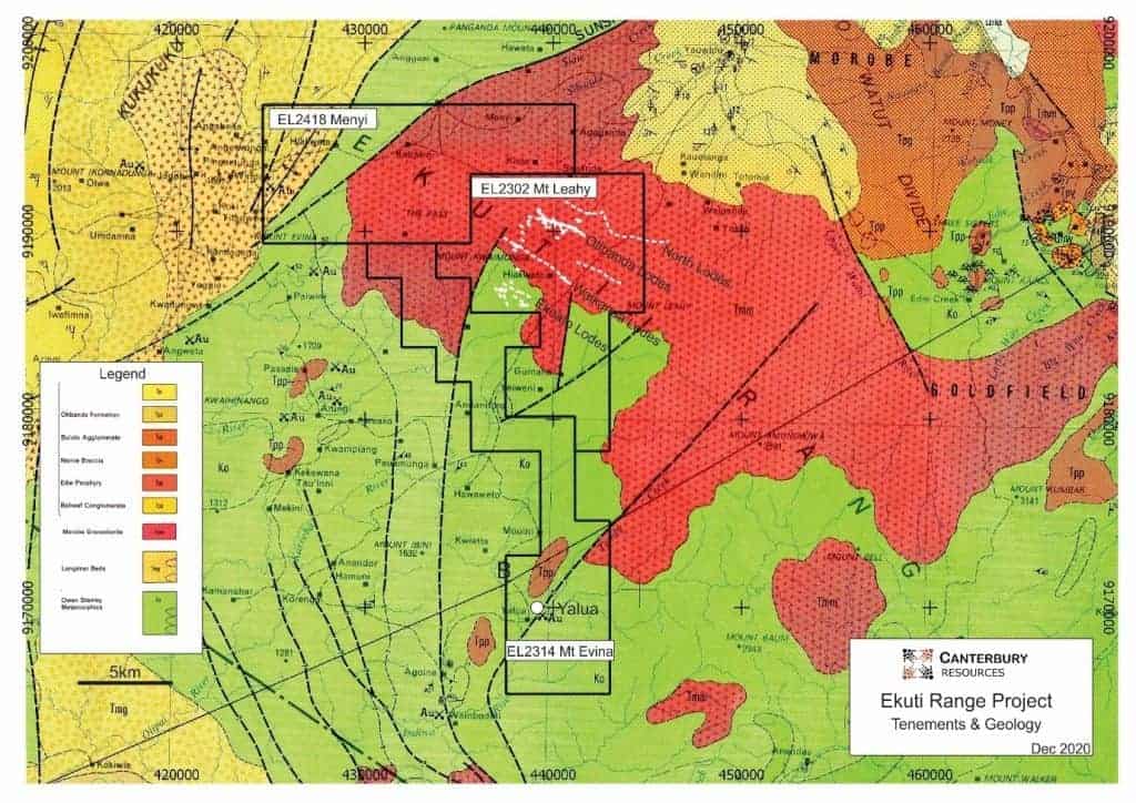
Ekuti Range tenements and regional geology showing location of Otibanda lodes
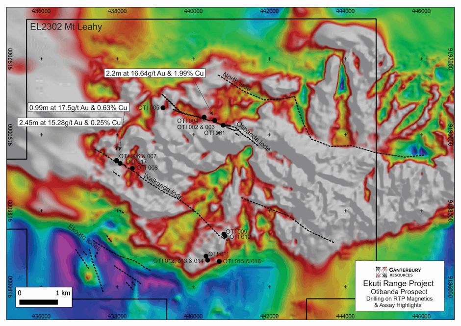
Otibanda – Waikanda – Ekoato lodes within EL2302 on magnetics, location of TPJ’s drill holes and significant gold and copper assays
BISMARCK PROJECT
The Bismarck Project (ELs 2378 and 2390) is located on central Manus Island in northern PNG, some 830km north of Port Moresby. The tenements cover a porphyry copper and gold province that is 35km long and 7km wide, with the mineralised corridor having a north-west south-east orientation. Manus Island’s commercial centre, Lorengau township, is in the east of the island and has a regular air service to Port Moresby.

The Bismarck EL’s were granted to Finny Ltd (“Finny”) in December 2015, and Finny was subsequently acquired by Canterbury in 2018. In September 2016 Rio Tinto Exploration (PNG) Ltd entered a Farm-In and Joint Venture Agreement (“JV”) with Finny whereby Rio Tinto has the right to earn equity in, and potentially acquire, the Bismarck Project. Under the JV, Rio Tinto has sole-funded more than A$5 million of exploration activity during the Initial Exploration and Stage-1 Exploration phases to earn a 60% JV interest in the Project. If Rio Tinto completes the Stage-2 Exploration phase, including sole-funding a further $12.5 million of exploration activity and drilling a minimum of 1500m, it will increase its JV interest to 80%.
Geologically, Manus Island is part of a dismembered volcanic arc on the Pacific Plate. The oldest exposed rocks are mid-Eocene to early Miocene volcanic rocks with calcareous interbeds and limestone lenses. Renewed volcanic activity is marked by the deposition of the Tasikim Volcanics, considered to be the extrusive equivalents of the large, early to middle Miocene multiphase quartz monzodiorite of the Yirri Intrusive Complex.
All copper and gold mineralisation on Manus Island appears to be genetically related to the Yirri Intrusive Complex. Preserved roof pendants within the Yirri Intrusive Complex are typically intensely brecciated and pyrite-silica-alunite altered, characteristic of high-sulphidation epithermal systems. Elsewhere hydrothermal alteration is more typical of deeper-seated porphyry copper mineralisation, and in the southeast of the mineralised corridor low-sulphidation epithermal vein and limestone replacement mineralisation occurs.


Detailed geology of the Yirri Intrusive Complex and main prospects
The region has undergone extensive and locally intensive early-stage exploration over the past 50 years, including more than 5,000 stream sediment samples, 1,500 rock chip samples, 6,000 soil samples and 102 diamond drill holes. However, historical drilling has failed to delineate any economic deposits.
Two main mineralisation styles are recognised, with strong potential for a third.
- Gold bearing low sulphidation epithermal quartz veins
- Low-grade porphyry-style copper ±gold ±molybdenum mineralisation hosted in the Yirri Intrusive Complex, and
- Potential high sulphidation copper-gold systems associated with extensive areas of silica-alunite lithocap.
Recognition of extensive lithocap in the southeast of the ELs has significant implications in the ongoing exploration for porphyry mineralisation. Lithocaps, defined as zones of advanced argillic alteration, may form above porphyry systems and may host late-stage metal-rich ore zones e.g. the Wafi gold deposit. Fertile lithocaps may also vector to concealed sizeable porphyry copper-gold deposits at depth e.g. the Golpu copper-gold deposit.
Rio Tinto’s exploration efforts since 2016 have assessed potential mineralisation associated with the lithocap through a combination of mapping, geochemical sampling and geophysics:
- Mapping has provided ample evidence of a well-developed advanced argillic lithocap.
- Re-interpretation of historical geochemical data has identified broad areas of coincident molybdenum, arsenic and bismuth over the lithocap area.
- Geophysics has identified buried potential porphyry style targets.
Rio Tinto’s geophysical activity commenced with a 786-line kilometre ZTEM survey, completed in March 2017. ZTEM (Z-Axis Tipper Electromagnetic) is an airborne audio-frequency magnetics system for electromagnetic surveying. It utilizes the naturally occurring or passive electro-magnetic fields from worldwide thunderstorm activity as the source of transmitted energy and is regarded as being suited to mapping deeply buried, porphyry hosted and structurally controlled deposits.
The Rio Tinto survey identified three significant anomalies that warranted further work (Main ZTEM Anomaly, ZTEM Anomaly 2, and ZTEM Anomaly 3). Evaluation of the Main ZTEM Anomaly concluded it was indicative of a resistive zone, interpreted as an intrusive stock, 500m in diameter with a conductive halo, interpreted as a sulphide zone, and comparable in size and clarity to the anomaly associated with the Wafi-Golpu deposit.
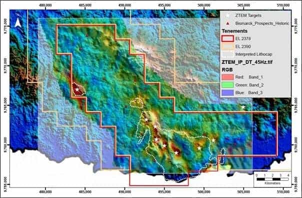
Location of main ZTEM targets and outline of lithocap
In late 2017 a 64-station Audio Magneto Telluric (AMT) survey was completed to verify the identified ZTEM anomalies. The AMT results suggested that the conductive (sulphide) targets are present at shallower depths than that suggested by the ZTEM alone, with the lithocap interpreted to be less than 100m thick in most of the priority target areas.
Rio Tinto proposed an initial diamond drill program of a minimum of 1,500m in three to five holes (DH001 to DH005) to initially test the Main ZTEM Anomaly area – an area that has not been previously drill tested.
Helicopter-supported diamond drilling at BISM0001 (site 001) commenced in 2018 and was terminated in early 2019. Adverse ground conditions, poor penetration rates and unacceptable operating costs resulted in terminating drilling of BISM001A ( a redrill of BISM0001) at 175.2m down hole. Only minor intervals of elevated copper were recorded, associated with limited occurrences of volcanoclastic rocks. It was not confirmed whether BISM0001A tested the interpreted ZTEM-AMT conductor.
A potential resumption of drilling is proposed following completion of the 2022 mapping and sampling program, traversing high priority creeks with anomalous geochemistry and mineralogy around the Chiniwea, Dremsel and Tahi prospects to better define porphyritic intrusions, porphyry related mineralisation, alteration and veining.
Any future drilling programs will seek to utilise an extensive network of tracks and roads that have been established in the area, which should enable the use of track mounted equipment.
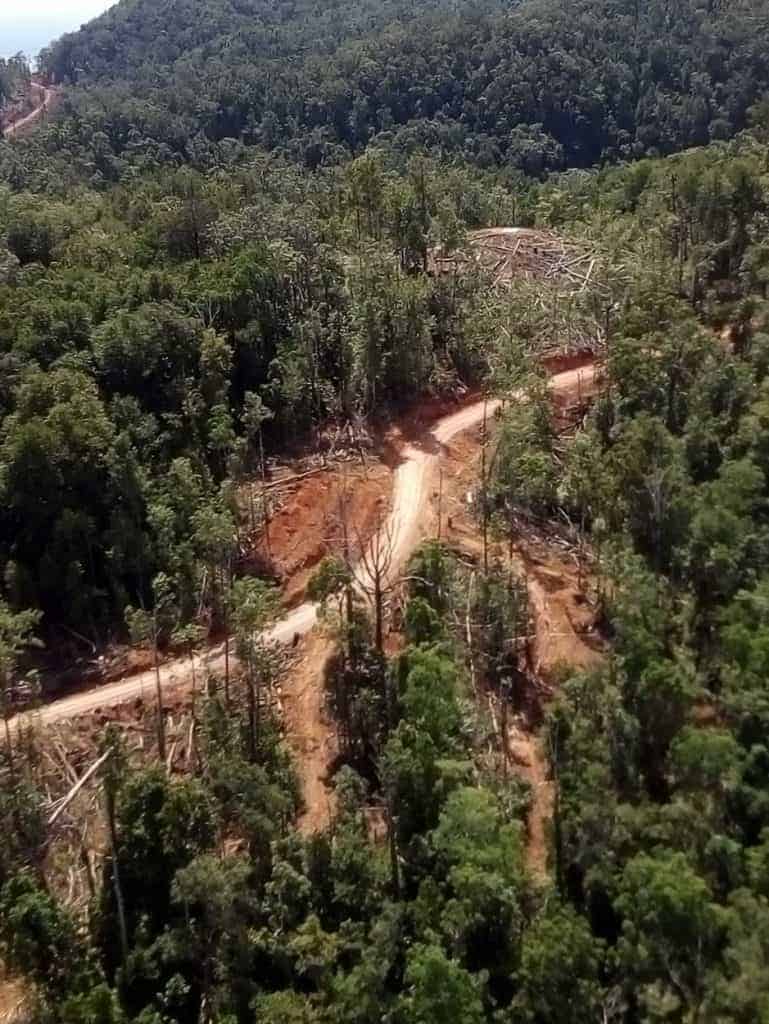
Recently constructed forestry tracks in the Mt Kren (lithocap) area, potentially providing ease of access for track mounted drilling equipment
BISM0001 drill core showing quartz-sericite altered volcanoclastic rocks with sulphide rich veins, all indicative of advanced argillic alteration in a lithocap environment
WAMUM PROJECT
The Wamum tenement (EL2658), granted in January 2021, adjoins the Harmony-Newcrest project area in Morobe Province, PNG. Within EL2658 there are two porphyry style deposits at Wamum Creek and Idzan Creek. Since the discovery by CRAE in 1977 there has been a total of 31 diamond holes drilled to test these deposits by various companies including CRAE (11 holes, 1979-1980), Highlands Gold (5 holes, 1990-1991), Barrick (12 holes, 2008-2012) and most recently Newcrest (3 holes (2015).
At both Wamum Creek and Idzan Creek, porphyry style alteration and mineralisation are associated with breccias and dioritic intrusions hosted in andesitic volcanics. Zoned hydrothermal alteration, associated mineralisation and geochemistry at Idzan Creek occurs in a 900m by 300m linear zone that trends east-west. By contrast, hydrothermal alteration and mineralisation at Wamum Creek defines an anomalous zone that is 700m by 500m trending southwest-northeast. Both copper-gold deposits are characterised by predictable zonal arrangement of hydrothermal alteration from: an inner biotite-chlorite (K-feldspar-zeolite) → magnetite-actinolite-albite → actinolite ± albite → distal chlorite-epidote alteration. Metal grades are highest immediately adjacent to single intrusive phases. Chalcopyrite veins, veinlets and disseminations overprint pervasive biotite (± k-feldspar-albite) alteration. Massive centimetre-scale chalcopyrite veins have been intersected.
Following the acquisition of all relevant historical exploration and drilling data in 2020, Canterbury generated geological models of the Idzan Creek and Wamum Creek deposits and engaged external consultants Bluespoint Mining Services (BMS) to undertake a Mineral Resource estimation. The Mineral Resource estimates were classified as Inferred, based on the relatively broad spacing of drill hole data, combined with the continuity and predictability of the mineralisation system.
The total contained metal for the overall Wamum Project is 3.16Moz Au and 762kt Cu.
| Deposit | Classification | Cut-off | Tonnes | Gold | Copper |
| Idzan Creek | Inferred | 0.2g/t Au | 137.3Mt | 0.53g/t | 0.24% |
| Wamum Creek | Inferred | 0.2% Cu | 141.5Mt | 0.18g/t | 0.31% |
Planning has commenced for a scoping study to assess the potential development of a stand-alone mining operation. Preliminary metallurgical testwork has been completed, achieving encouraging copper and gold recoveries via conventional processing (crush-grind-flotation).
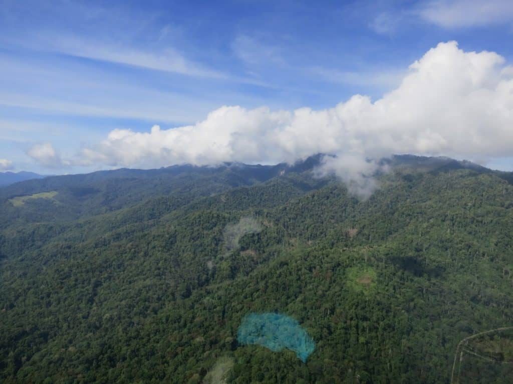
View south west over the Wamum project area
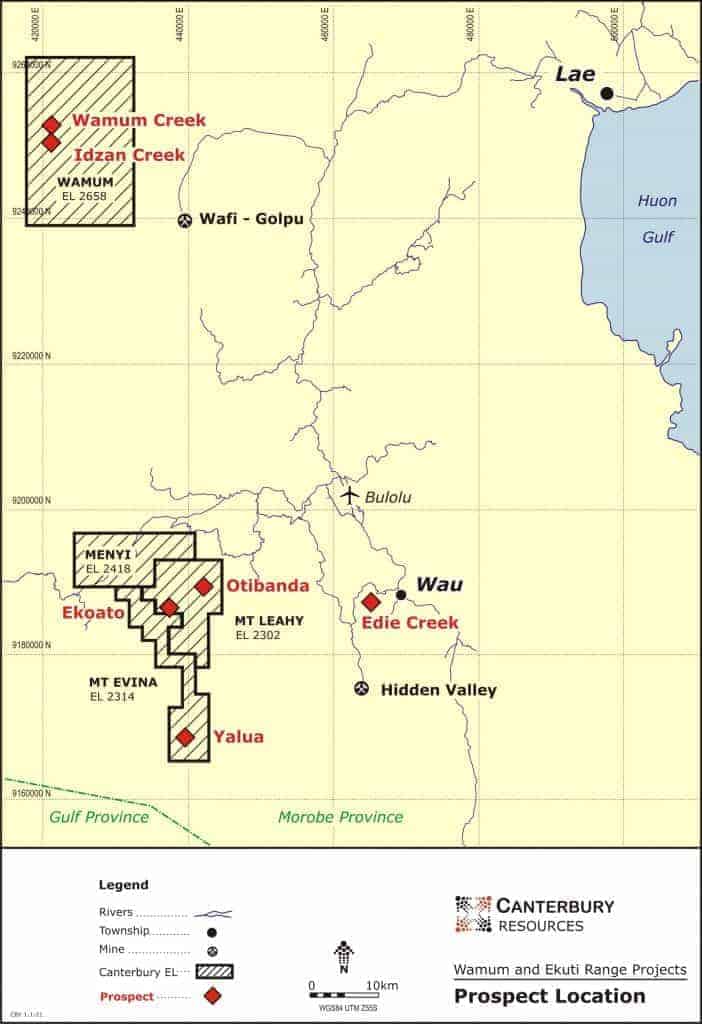
Wamum tenement (EL2658) located 60km west of Lae and north west of the Wafi-Golpu copper-gold project of Newcrest-Harmony
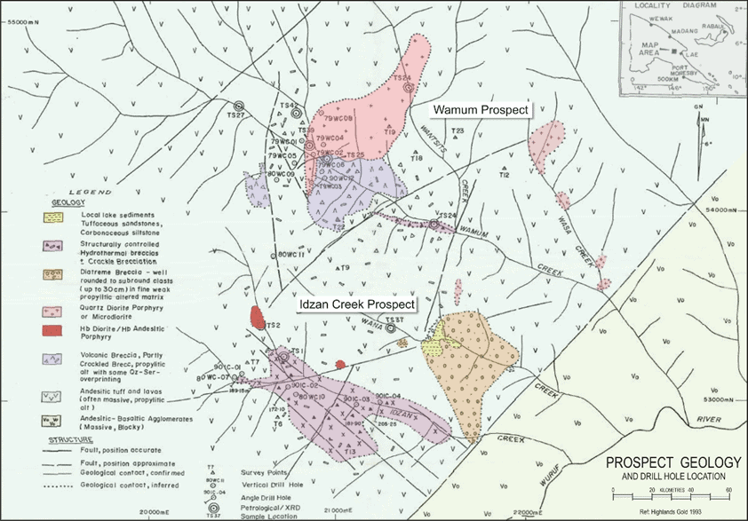
Geological map of the Wamum Creek and Idzan Creek prospects
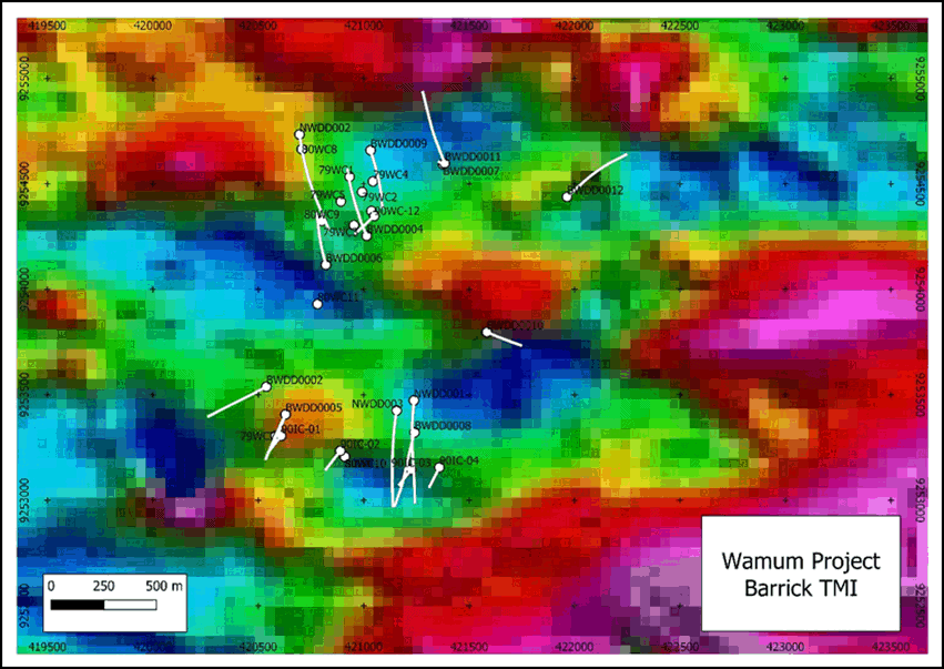
Wamum Creek and Idzan Creek prospects, TMI magnetics and drill hole traces
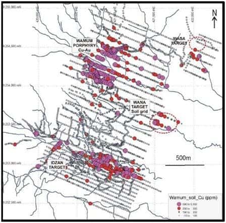
Wamum project, CRAE and Highlands Gold copper soil and bedrock (Wacker) geochemistry

Wamum diatreme breccia: monomict (left) and polymict (right)
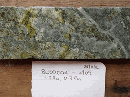
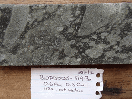
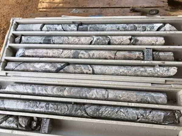
Wamum Creek, drill hole BWD0004 (with hole depth, plus copper and gold assays for sample interval)

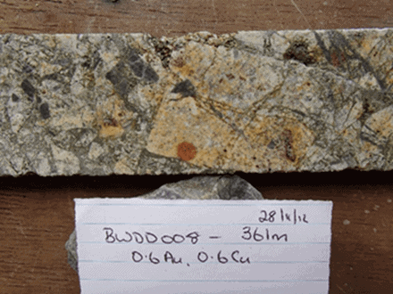
Idzan Creek, drill hole BWD0008 (with hole depth, plus copper and gold assays for sample interval)

Comparison of ZTEM anomaly at Wamu-Idzan with Golpu ZTEM anomaly, illustrating similarities
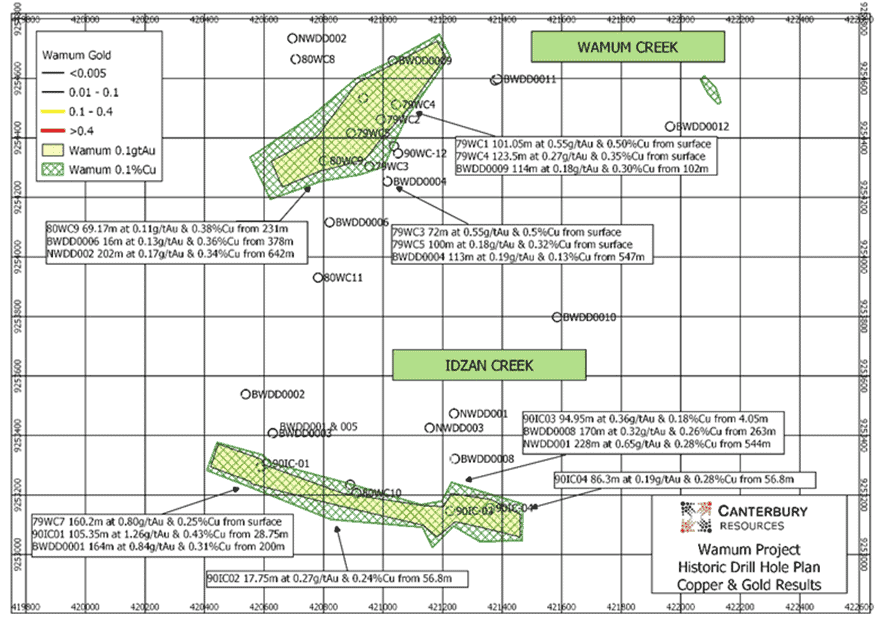
Wamum Creek and Idzan Creek prospects, copper (+0.2%Cu) and gold (+0.1g/t Au) mineralised envelopes used in resource estimation, and significant copper and gold drill assay results
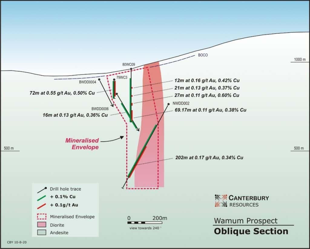
Drill section, Wamum Creek prospect

Drill section, Idzan Creek prospect